
GIS
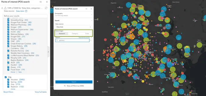
Unveiling the Latest Enhancements in ArcGIS Business Analyst Enterprise: May 2024 Update
Esri has announced an exciting array of updates in the May 2024 release of ArcGIS Business Analyst Enterprise, enhancing its capabilities for businesses seeking to leverage geographic data for better
Ordnance Survey Expands as a Distributor of Third-party Government Data
Ordnance Survey (OS), Great Britain’s leading geospatial data provider, and BGS, the UK’s leading scientific earth data provider, both Geo6 members, are driving an exciting new development. It is the

GAF AG Awarded Contract for CAP-Area Monitoring 2024 in Bavaria
As part of an ongoing process of reforms to modernise and simplify the EU’s CAP, since January 2023 the monitoring of subsidy payments has been carried out on the basis
What Are the Uses of GIS for Business?
Like other modern industries, Geographic Information Systems (GIS) have gained popularity in the business world these days. GIS has proven to be useful and has gained traction in many areas

How Much Are Salaries in the Geospatial Industry
Have you ever wondered about the financial rewards of a career in the rapidly evolving geospatial industry? This interdisciplinary field, merging geography with cutting-edge technology, is not only fascinating but

Impact Of Advancements in Computational Mathematics on Geospatial Technology
Advancements in geospatial technology have led to incredible progress in various sectors, from urban planning to environmental management. Among the many factors contributing to this progress, computational mathematics takes center
Branding a Geospatial Company – Step to Step
Establishing a brand for your geospatial company is key to your success and can be overwhelming if you need help knowing where to start. This blog will provide a step-by-step

How to Improve Sales in the Geospatial Industry
It’s true — the digital mapping and analytics world is rapidly expanding, opening up new opportunities for businesses that know how to leverage this technology. However, despite its technological advancements

Which Cloud GIS Software to Choose?
The best cloud platform should be chosen for GIS projects because it will have a big impact on their success. For GIS projects, cloud computing offers a variety of benefits,

Collaboration Between Survey of India and Genesys for Advanced 3D Digital Twin-Mapping Initiative in India
Genesys International, a domestic mapping firm, has entered into a partnership with Survey of India to harness its capabilities in creating 3D digital twins for significant towns and cities across
