
Business

Supergeo Announces Partnership with T&B Radio Tech in Korea
Supergeo Technologies, the leading global provider of complete GIS software and solutions, authorized T&B Radio Tech, Republic of Korea, as a certified reseller to promote SuperGIS in information communication technology

Esri and E2open Partner to Deliver Market-Leading Supply Chain Solutions
Customers to Benefit from Rapid Demand-Supply Network Visualization on a Global Scale December 8, 2014 Redlands, California—E2open, the leading provider of cloud-based solutions for collaborative planning and execution across global trading

Autodesk Makes Design Software Free to Schools Worldwide
Design Software Leader Expands Reach of Free Education Offering to Prepare an Industry-ready Workforce Fulfilling its promise to expand access to its professional design software in education, Autodesk, Inc. (NASDAQ:ADSK)

SuperSurv 3.2 Supports iOS 8 and Enhances GPS Display
SuperSurv (iOS) 3.2, the field data collecting app for iPhone and iPad users, now fully supports iOS 8 and enhances GPS display with optimal user experiences. Developed by Supergeo, SuperSurv
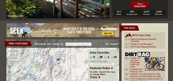
USGS to Show Mountain Bike Trails on US Topo Maps
Get Your Wheels Spinning As part of the continued US Topo maps revision and improvement cycle, the USGS will be including mountain bike trails to upcoming quadrangles on a state-aligned

Government of South Australia Releases Geoscientific Data
The State Government has released a major package of geoscientific data in one of the State’s most underexplored provinces. Speaking today at the 8th annual Mining South Australia Conference in
Supergeo Extends Free SuperGIS Desktop License Policy for Students
Supergeo Technologies, the leading GIS software provider, announced the extended policy of free SuperGIS Desktop 3.2 license for students. The universities, colleges and high schools that purchase SuperGIS Desktop Lab
3D Laser Mapping Scanner Helps UCL Scientists Map Trees
A state of the art laser scanner purchased from 3D Laser Mapping is helping scientists at University College London accurately monitor and record the state of forests around the world.

ThinkGeo Releases Map Suite for Android, iOS and WebAPI
Frisco, TX — ThinkGeo is proud to announce the additions of Map Suite WebAPI , Map Suite for Android and iOS platforms to the Map Suite family of products. These

HERE Launches Predictive Traffic
Charlotte, N.C. – HERE, a leader in navigation, mapping and location experiences, today launched Predictive Traffic, a new traffic forecasting product that can anticipate future traffic conditions in real-time. HERE
