
Tag "geospatial"

Bluesky Launches New Online Resource for Geographic Information of Ireland
Aerial mapping company Bluesky has launched a new online Mapshop to serve the rapidly expanding mapping and geographic information industry in Ireland. With tens of thousands of square kilometres of

Swiss Geospatial Data Now Available as Linked Data
The Swiss geoportal has started to publish geospatial data as linked data. This geoportal is harvested by the national Swiss Open Data portal, which is in turn harvested by the

OGC Requests Public Comment on Proposed Indexed 3D Scene Layers (I3S) Community Standard
The Open Geospatial Consortium (OGC®) is requesting public comment on the proposed Indexed 3D Scene Layers Community Standard. Indexed 3D Scene Layers (I3S) was submitted by Esri for consideration as
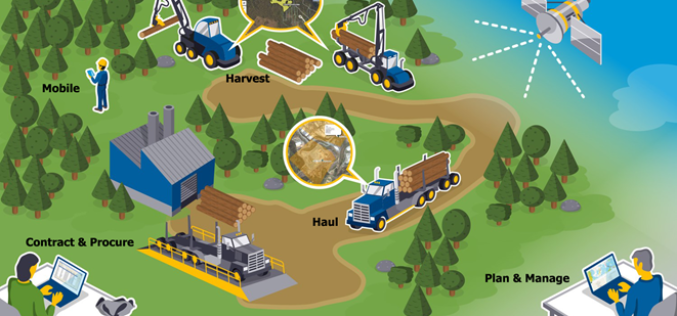
New Forests to Manage its Asian-Based AFI Investment with Trimble’s Connected Forest Solution
SUNNYVALE, Calif., March 22, 2017—Trimble (NASDAQ: TRMB) announced today that New Forests, a Sydney-based sustainable real assets investment specialist, will implement Trimble’s Land Resource Manager (LRM) solution to manage its
Trimble and Ordnance Survey Collaborate to Aid Geospatial Industry Innovation
An exciting new relationship between Trimble and Ordnance Survey (OS) sees innovators at the Geovation Hub leverage Trimble’s latest technologies. Innovators at Ordnance Survey’s Geovation Hub, a group ranging from Big Data
OGC Seeks Public Comment on proposed Unmanned Systems Domain Working Group
The Open Geospatial Consortium (OGC®) seeks comments on the draft charter of a proposed Unmanned Systems Domin Working Group (UXS DWG). The proposed DWG will provide an open forum for
FICCI Report Highlights Importance of Geospatial Technologies in India
A report released by the Federation of Indian Chambers of Commerce and Industry (FICCI) suggested that the need-based pull for usage of geospatial tools and data has begun. From the
Gender Data in GIS Helps Reduces Climate Change Impacts
New Delhi, India – Gender in Geographic Information System (GIS), though new, plays a significant role in helping disaster risk management, and reducing environmental and climate change impacts in vulnerable
Geospatial Information and Technology Association (GITA ) 2017 Scholarship Program
Geospatial Information and Technology Association (GITA ) is involved in professional education activities throughout the year generate funds which are used to award scholarships to deserving students. These scholarships are
K2 Geospatial Launches the Latest Version of its Map-based Integration Platform JMap
More powerful, even more robust and interoperable, JMap 7 is now available JMap’s 7th version is finally here! K2 Geospatial, a leading map-based solution developer, is proud to announce the release
