
Tag "GIS"
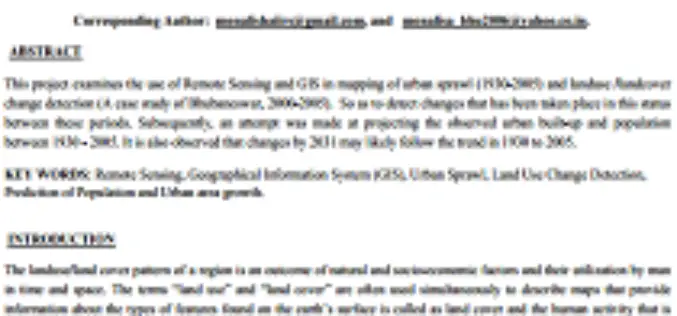
Urban Sprawl Mapping And Land Use Change Analysis Using Remote Sensing And GIS (Case Study Of Bhubaneswar City, Orissa)
Urban Sprawl Mapping And Land Use Change Analysis Using Remote Sensing And GIS (Case Study Of Bhubaneswar City, Orissa) Monalisha Mishra, Kamal Kant Mishra, A.P. Subudhi Abstarct: This project examines
Pakistan to Adopt Remote Sensing and GIS Based Flood Mitigation System
In recent news by The Express Tribune, Pakistan Space and Upper Atmosphere Research Commission (SUPARCO) in collaboration with UNESCO will install satellite remote sensing and GIS technologies across Pakistan for
Dehradun Municipal Corporation Fails to Put GIS into Property Assesment
In a recent news by Hindustan Times, the Dehradun Municipal Corporation (DMC) has failed to put into use the Geographical Information System (GIS) for mapping properties in the state capital. In the

World Bank Credits $153 Million to Odisha Disaster Recovery Project
In a recent news, World Bank has approves a $153 million to the state of Odisha in India to strength its capacity for disaster risk management and to build disaster

As of No GIS Road Information for Nagaland
In recent news, there is no proper mapping or network database of roads for the entire state of Nagaland. It may be that entire world is enjoying the extensive road

Federal Agencies ‘Mapping and Apping the Nation’
Maps today are much more than an outline of shapes and landmarks. We use them all the time in combination with the vast amount of information available online to plan

Vellore Corporation Introduce GIS for Streetlight
The Vellore Corporation is initiating a high-tech system to monitor and maintain streetlights. Geographic Information System (GIS) to monitor streetlight would be implemented as a public-private partnership project at an

GIS Governance for Tamil Nadu State, India
In recent news, Government of Tamil Nadu has announced the implementation of Geographical information System (GIS) for Tamil Nadu state. Tamil Nadu Geographical Information System (TNGIS) is an initiative to ensure

GIS to Locate Exact Electricity Snag in India
In a recent news, New Okhla Industrial Development Authority (hereinafter referred to as “NOIDA” or “the Authority”) in India has moved to insure better facilities to its electricity consumers. The Noida Discom

California’s Gateway Cities Launch Sophisticated GIS Planning Web Tool
The 28 municipalities in the Gateway Cities Council of Governments in southeastern Los Angeles County have teamed up to launch a groundbreaking new website, GatewayCOGSiteProspector.org, to attract businesses and jobs. Using
