
Tag "ISRO"

Satellite Reveals Decline in the Number of Forest Fires in Uttarakhand
According to recent news by The Hindu, Satellite images show that there’s been a decline in the number of forest fires in Uttarakhand since April 28. Though fires in the
Punjab Government to Utilise Remote Sensing Satellites for Development
Punjab government on Monday said India should make use of its remote sensing satellites more efficiently for development in agriculture and rural and urban planning. “India, having the largest constellation
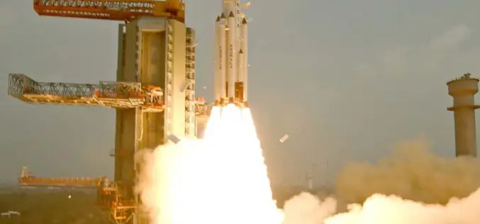
Cartosat-2C to Boost Military Surveillance
According to recent news by The Indian Express, ISRO’s earth observation satellite Cartosat-2C will be launched in May using a PSLV rocket. It will prove to be a shot-in-the-arm for India’s
ISRO to Monitor Water Bodies in Tribal Areas Using Geospatial Technology
New Delhi – In a first, ISRO’s National Remote Sensing Centre (NRSC) will monitor and map the water bodies in tribal belts in the country to help tackle irrigation crisis

ISRO, Indian Railways to Sign MoU Over Remote Sensing and GIS
NEW DELHI: Aiming at effective use of space technology in remote sensing and graphic information system (GIS) based applications, Railways is set to join hands with Indian Space Research Organisation
ISRO to Double Missions to 12 Per Year
Having launched 55 missions in space in the last five years, the national space agency ISRO is looking at doubling the number of missions in the next five years to
Delhi Police to Use Space Tech for Crime Control
The Delhi Police will soon start using space technology for live crime mapping and adopting a “predictive policing” mechanism being developed in partnership with the Indian Space Research Organisation. “The

ISRO Conducts 1st Satellite-based Warning system for Railways
According to recent news by The Indian Express, the first trial run for developing a satellite-based system to warn train drivers of unmanned railway crossings was conducted by ISRO scientists

Cabinet Apprised of ISRO-KISR MoU for Joint Space Exploration
New Delhi, Jan 20, 2016 – The Union Cabinet was today apprised of an agreement between ISRO and a Kuwaiti research body on cooperation in exploration of outer space and
India Successfully Launches Fifth Navigation Satellite IRNSS-1E
ISRO’s Polar Satellite Launch Vehicle, PSLV-C31, successfully launched the 1425 kg IRNSS-1E, the fifth satellite in the Indian Regional Navigation Satellite System (IRNSS) on January 20, 2016, from Satish Dhawan
