
Tag "remote sensing"

Pakistan to Launch First Remote Sensing Satellite by 2018
Islamabad [Pakistan], According to recent news by the ANI, with space technology being used in the planning and monitoring of China-Pakistan Economic Corridor (CPEC) projects, the Pakistan Space and Upper

PCI Geomatics and PrecisionHawk Enter into Long Term Partnership
MARKHAM, Ontario, Canada—September 20, 2016: PCI Geomatics, a world-leading developer of remote sensing and photogrammetric software and systems, announced today it has entered into a long-term partnership with PrecisionHawk, a
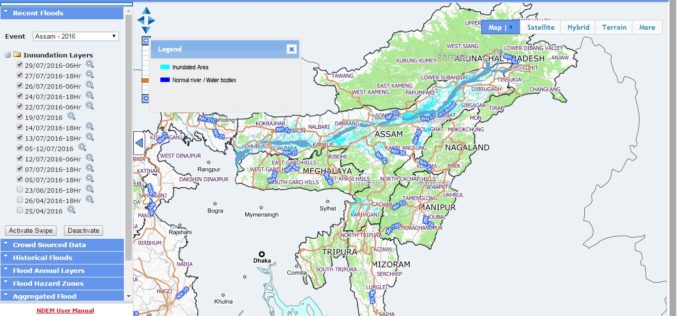
NRSC Released Updated Flood Hazard Atlas for Assam State
According to recent news by ISRO, the National Remote Sensing Centre (NRSC), ISRO, Hyderabad has released updated flood hazard atlas of Assam, a highly flood-prone state of India. Assam is

NASA ARSET – Remote Sensing Training: Methods & Best Practices
Remote Sensing Training: Methods & Best Practices Thursdays, October 13-27, 2016 10:00 – 11:30 a.m. and 5:00 – 6:30 p.m. EDT (UTC-4) The goal of the NASA Applied Remote Sensing

UAE to Adopt Space Technology for Farming
According to the recent news reported by the Gulf News, the UAE Space Agency has recently hosted senior Japanese officials at its Abu Dhabi headquarters for talks on applying space

DLR and CNES Sign an Agreement for the Construction and Operation of the MERLIN Environmental Satellite
On 14 September 2016 in Berlin, the German Aerospace Center (Deutsches Zentrum für Luft- und Raumfahrt; DLR) and the French space agency (Centre national d’études spatiales; CNES) signed a cooperation

DLR Fire Detection Satellite BIROS Successfully Releases BEESAT-4 Picosatellite into Space
On 9 September 2016 at 13:00 CEST, the BIROS (Bi-Spectral Infrared Optical System) fire detection satellite developed and built by the German Aerospace Center (Deutsches Zentrum für Luft- und Raumfahrt;
Orbit Logic Adds Worldview-4 to DigitalGlobe Planning Software
GREENBELT, MD (September 7, 2016) – Orbit Logic announced today that it is delivering to DigitalGlobe, Inc. (NYSE: DGI), an updated version of its Direct Access Facility Collection Planning System

ASTEC Launches Space-based Program for Empowering Panchayati Raj Institutions
Guwahati, India -According to recent news reported by The Assam Tribune, the Assam Science Technology and Environment Council (ASTEC) has launched outreach activities for space-based projects Empowering Panchayati Raj Institutions

NESAC Technology to Monitor Progress of 700 NEC Projects: India
Umiam (Meghalaya), Sep 5 (PTI) – Around 700 government projects funded by the North Eastern Council, which are facing delay and cost over-run in eight states of the north east
