
Tag "remote sensing"

Belarus and Russia Jointly to Develop Remote Sensing Satellite
As reported in BELTA News Agency, in a statement made by Chairman of the Presidium of the National Academy of Sciences of Belarus (NASB) Vladimir Gusakov as he met with

Doctoral Candidate Position in Remote Sensing of Vegetation
Aalto University is a new university with over a century of experience. Created from a high-profile merger between three leading universities in Finland – the Helsinki School of Economics, Helsinki
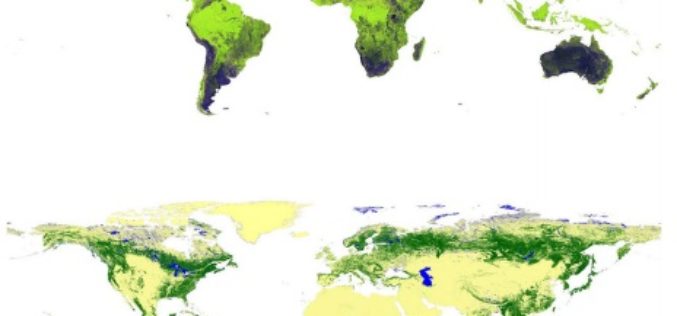
Global Forest Watch Using High Resolution Synthetic Aperture Radar
Forests always have been an important for all human beings and animals. For some forests provide shelter and some forests are source of livelihood. Monitoring global forest footprint is of
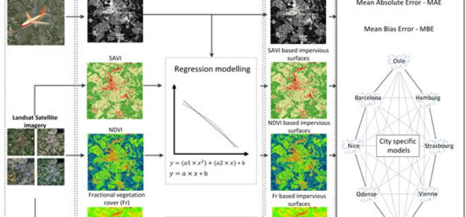
Using Landsat Vegetation Indices to Estimate Impervious Surface Fractions for European Cities
Using Landsat Vegetation Indices to Estimate Impervious Surface Fractions for European Cities – Kaspersen, P.S.; Fensholt, R.; Drews, M. Using Landsat Vegetation Indices to Estimate Impervious Surface Fractions for European Cities.

A New Era of Space Collaboration between Australia and U.S.
On June 18, 2015 in Canberra, Australia, the U.S. Geological Survey and Geoscience Australia signed a comprehensive new partnership to maximize land remote sensing operations and data that can help

Postdoctoral Opportunity in Earth and Environmental Science, Temple University
The Department of Earth and Environmental Science offers students the opportunity to study the Earth with a variety of traditional and environmental geology course work. The faculty work closely with

Nominations Open for the Prestigious Carl Pulfrich Award 2015
Heerbrugg, Switzerland, 26 May 2015 – Hexagon Geosystems is pleased to continue the tradition of promoting outstanding scientific, application-oriented design and/or manufacturing activities in the field of photogrammetry, remote sensing
Delhi Govt to Use Remote Sensing Technology to Check Illegal Construction
New Delhi – May 20, 2015: Delhi Government on Wednesday said it will use remote sensing satellite technology to check and map unauthorised constructions and encroachments in the city and

India and Vietnam to Cooperate in Earth Observation Technology
In a recent visit by the delegation of the Vietnamese ministry to India, a joint decision between India’s Ministry of External Affairs, Department of Space, and Space Research Organisation and
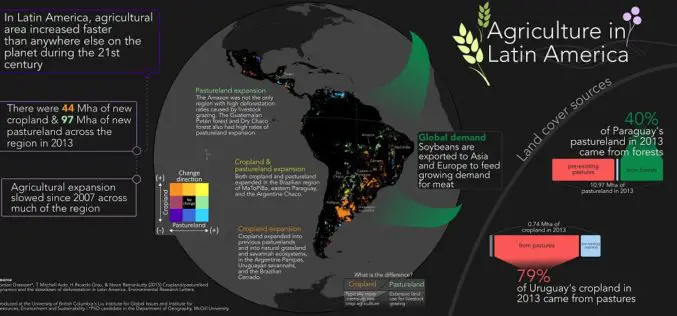
Remote Sensing to Study Dynamics of Cropland in Latin America
In a study, “Cropland/pastureland dynamics and the slowdown of deforestation in Latin America,” published in Environmental Research Letters by Jordan Graesser and et. al., brings out some interesting facts about
