
Tag "remote sensing"
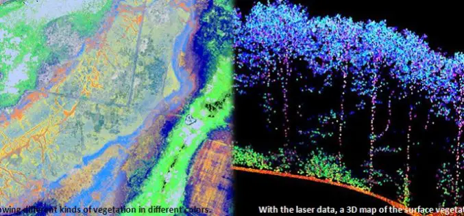
Protecting Nature Using Airborne Laser Footprint Data
In a study by Prof. Norbert Pfeifer at the Vienna University of Technology, reveals the significance of using airborne laser technology in protecting nature. The study area is ‘‘Nagyerdo˝’’ (Great
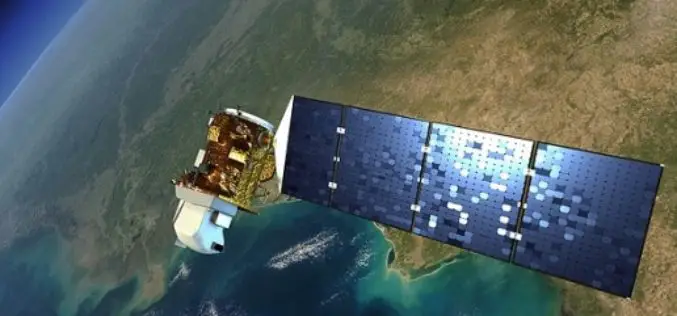
Landsat 9 to Continue Land Imaging Legacy of the U.S. Space Program
In recent news update by NASA, NASA and USGS are working together on Landsat 9, schedule to launch in 2023. NASA will build, launch, perform the initial check-out and commissioning
Over 20 Concepts For Applied Projects In “Remote Sensing Applications Competition” Launched By EIAST
The competition aims to develop mechanisms and programs that serve various governmental sectors As part of the Remote Sensing Applications Competition 2014, launched by the Emirates Institution for Advanced Science

NRSC Offering Special Course on Microwave Remote Sensing Applications
National Remote Sensing Agency (NRSA) was established as a registered society on 2nd September 1974 by Department of Science & Technology, based on a Union Cabinet approval dated December 13,
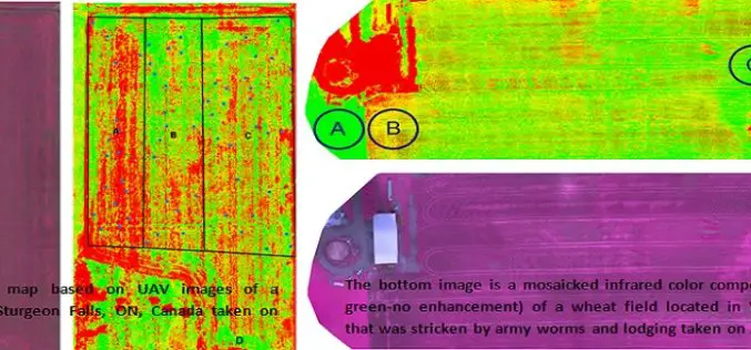
Applications of Low Altitude Remote Sensing in Agriculture
In a study by Chunhua Zhang et. al., on “Applications of Low Altitude Remote Sensing in Agriculture upon Farmers’ Requests– A Case Study in Northeastern Ontario, Canada” reveals the importance

Introduction to GIS for Agriculture: Rangeland Focus Workshop
Introduction to GIS for Agriculture: Rangeland Focus Workshop Wednesday, April 15th, 2015, from 8:00am to 1:00pm Informatics and GIS Program (IGIS) by University of California aims to support research technology

NASA ARSET Course on Introduction to Remote Sensing for Conservation Management
The goal of the NASA Applied Remote Sensing Training (ARSET) is to increase the utility of NASA earth science and model data for policy makers, regulatory agencies, and other applied

Call for Papers – Geospatial Applications of Big Data Analytics
Recent developments in information technology commonly referred to as ‘Big Data’ along with the related fields of data science and analytics will need to be brought to bear in order
Tribal Ministry to Use Satellite Mapping to Develop Water Bodies
The Ministry of Tribal Affairs (MoTA) is planning to use satellite mapping to identify potential water collection spots, which could be developed for fish culture and other purposes in order
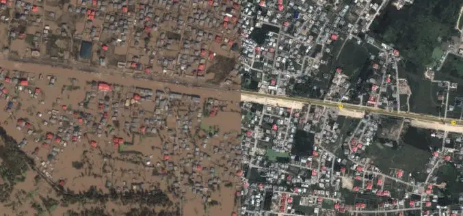
Kashmir Floods Monitored By Latest Satellite Technology
Union Minister Jitendra Singh said that Kashmir floods are being constantly monitored by latest satellite technology at the National Remote Sensing Centre. “Kashmir floods are being constantly monitored by latest
