
Tag "GIS"

ThinkGeo Releases Map Suite for Android, iOS and WebAPI
Frisco, TX — ThinkGeo is proud to announce the additions of Map Suite WebAPI , Map Suite for Android and iOS platforms to the Map Suite family of products. These

TerraGo Unveils Groundbreaking OpenGeoPDF Technology
OpenGeoPDF is a collection of technologies that combine open spatial database features and application logic within portable, intelligent maps. TerraGo, a leading global provider of location intelligence solutions, is pleased

UNESCO-IHE is Offering Open Courseware on Preprocessing GIS Data for Hydrological Models
UNESCO-IHE is committed to solving the world’s water crisis by educating the water leaders of the future, particularly those from developing countries and countries in transition. The demand for water
eCognition Essentials-Powerful Out-of-the-Box Land Cover Mapping Solution
eCognition Essentials is a new software solution for geospatial and remote sensing professionals performing land cover mapping tasks using imagery. eCognition Essentials offers an intuitive image analysis solution that allows users
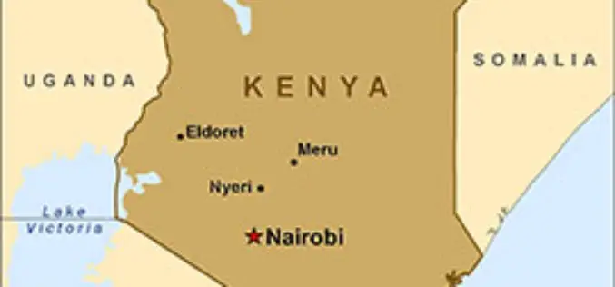
Geospatial Technology for National Planning
In recent news, Kenya is planning to use geospatial technology in its national planning process to facilitate governance. Cabinet Secretary in the Ministry of Devolution and Planning Anne Waiguru told

Mapping Switzerland’s Danger Spots
A Landslide In Southern Switzerland Has Left Two Dead. The Area Hadn’t Been Included In National Danger Zone Maps. A wall above the property apparently collapsed after days of heavy

PhD in GIS and Remote Sensing at Motilal Nehru National Institute of Technology
Motilal Nehru National Institute of Technology Allahabad [MNNIT Allahabad], an Institution of National Importance declared by the Act of Parliament and a premier technical institution of the Country, offers several

Fiji Adopted GIS Technology to Boost Sugar Industry
In recent news, the Fiji’s Prime Minister Voreqe Bainimarama has launched GIS portal at the Sugar Cane Growers Building in Lautoka which will now see the digitisation of the sugar

Young GIS Practitioners Encouraged to Apply to URISA Vanguard Cabinet
URISA is pleased to announce the availability of the 2015 Vanguard Cabinet application. The Vanguard Cabinet (VC) is a URISA initiative which debuted in 2011 to engage young GIS practitioners

KU to Host 13th Annual GIS Day to Explore Innovations in Mapping Technology
On November 19, The University of Kansas will host the 13th annual GIS Day @ KU. The all-day event is part of a worldwide celebration that showcases recent developments and
